
March can be known for big swings in weather conditions. Apparently this March is no different! While the month was very mild and even warm to start, a significant storm system will impact the eastern part of the country this weekend. Rain, snow and plummeting temperatures will all be on the table...not to mention high winds behind the storm!
Of course...March snow can be finnicky due to increasing sun angle as well as average temperatures rising with each day. That being said, March snow is NOT unusual and lately has seemingly been a frequent occurrence in the region. Elevation will play a big role in this particular system (mountain will get more snow).
The 3km NAM model shows precipitation moving into the area tonight as rain. But as temperatures drop behind the area of low pressure, most areas change to snow. Areas to the west first, followed by areas close to the I-95 corridor. There may be a window for potentially heavy snow during the mid-morning hours. If there is to be accumulation, it will be during that time.
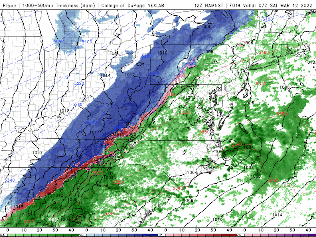 |
| The 12z (3/11) run of the 3km NAM model shows precipitation starting as rain before changing to snow. Some of the snow could be heavy during the mid-morning on Saturday. |
Warm antecedent conditions, increasing sun angle and the quick duration of the event will preclude a high risk of accumulation on area roads. However, the snow may come down heavy enough to make roads slippery and slushy for a period. The best chances for this will be to the north and west of the cities.
This is certainly an event where grassy or elevated surfaces may receive several inches of snow while roads stay mainly wet. It would still be wise to prepare to stay off the roads until the afternoon Saturday.
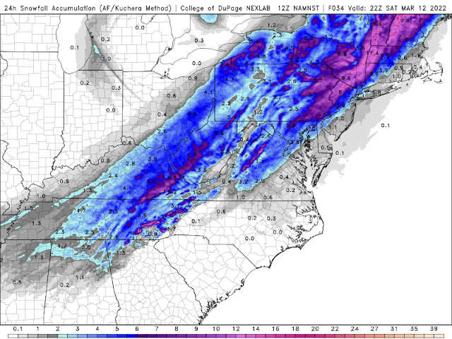 |
| The 12z (3/11) run of the 3km NAM showing snow accumulation potential even into the metro areas. This may be overdone by a bit. Nonetheless, a couple inches of snow is possible on mainly grassy surfaces. |
The other factor that will be a part of this storm are the winds. Due to the strength and deepening of the low pressure system, a strong pressure gradient (the difference between high and low pressures) will exist behind the storm. Some wind gusts at, or above 50mph are possible. If snow is wet and accumulates on trees/powerlines, some damage and outages could result.
All in all, this has the potential to be an impactful storm system for the reasons outlined above. Temperatures will be quite cold on Saturday night (especially in areas that have snow cover on the ground). All that being said, temperatures will quickly moderate (this will NOT be a long cold shot) and next week will feature 60+ degree temperatures. This could (and likely is) the last true gasp of winter...although it is entirely possible another cold shot or two could come later in the month or even into April.