Monday, August 7, 2023

Dangerous Severe Weather Expected Today

 Severe weather will threaten the region this afternoon and evening. There is the potential for the most significant severe weather episode in this area in the past 10 years today. That being said, some uncertainty and complicating factors remain to be worked out. 

The primary potentially limiting factor for severe weather will be morning clouds and/or rain. If clouds and precipitation do not clear out of the area by late morning, instability could be reduced enough to reduce the overall severe threat. The expectation is that regardless of amount of sun, SOME threat for severe thunderstorms will exist...but sunshine will only serve to increase the threat. 

At the time of this writing, the Storm Prediction Center has outlooked the "bullseye" of the severe weather risk for the DC/Baltimore area and surrounding areas. See the purple/pink area highlighted below. 

The purple/pink area is where the Storm Prediction Center has highlighted the greatest risk.

ALL severe weather types (damaging wind, hail and tornadoes) will be possible with the storms this afternoon. Of course, damaging wind will be the greatest threat, but low level shear is such that tornadoes can also spin up either in a line of storms, or in discrete cells that may form ahead of a more organized line. 

The 0z high-resolution NAM model depicts a very dangerous line of thunderstorms raking through the area in the early evening hours (see below).


One thing to keep in mind is that often times, storms tend to develop or come through the area a bit ahead of schedule. Therefore, while some modeling suggests 6-8pm as a timeframe for worst weather for the immediate metro area, I would be inclined to think it could be a bit earlier than that. Nonetheless, the time period from 2pm until 8pm bears watching - as any time in that timeframe could feature dangerous weather.

People will want to have multiple ways to receive watches, warnings and alerts. There will also be a non-zero flash flooding threat as well...so please DO NOT drive through any flooded roadways. Don't become a statistic. 

I would strongly suggest if possible, not being on the roads whenever this line of storms forms/moves through. Traffic is likely to be interrupted by both the rainfall as well as any associated damage. Power outages will also be likely in areas that receive the most significant weather. Charge your phones and portable battery packs NOW - so that you have them in the event of an outage. 

Stay safe! 

Friday, March 11, 2022

Sneaky March Snow to Impact Area

 March can be known for big swings in weather conditions. Apparently this March is no different! While the month was very mild and even warm to start, a significant storm system will impact the eastern part of the country this weekend. Rain, snow and plummeting temperatures will all be on the table...not to mention high winds behind the storm! 

Of course...March snow can be finnicky due to increasing sun angle as well as average temperatures rising with each day. That being said, March snow is NOT unusual and lately has seemingly been a frequent occurrence in the region. Elevation will play a big role in this particular system (mountain will get more snow). 

The 3km NAM model shows precipitation moving into the area tonight as rain. But as temperatures drop behind the area of low pressure, most areas change to snow. Areas to the west first, followed by areas close to the I-95 corridor. There may be a window for potentially heavy snow during the mid-morning hours. If there is to be accumulation, it will be during that time. 


The 12z (3/11) run of the 3km NAM model shows precipitation starting as rain before changing to snow. Some of the snow could be heavy during the mid-morning on Saturday.

Warm antecedent conditions, increasing sun angle and the quick duration of the event will preclude a high risk of accumulation on area roads. However, the snow may come down heavy enough to make roads slippery and slushy for a period. The best chances for this will be to the north and west of the cities. 

This is certainly an event where grassy or elevated surfaces may receive several inches of snow while roads stay mainly wet. It would still be wise to prepare to stay off the roads until the afternoon Saturday.

The 12z (3/11) run of the 3km NAM showing snow accumulation potential even into the metro areas. This may be overdone by a bit. Nonetheless, a couple inches of snow is possible on mainly grassy surfaces.

The other factor that will be a part of this storm are the winds. Due to the strength and deepening of the low pressure system, a strong pressure gradient (the difference between high and low pressures) will exist behind the storm. Some wind gusts at, or above 50mph are possible. If snow is wet and accumulates on trees/powerlines, some damage and outages could result. 

All in all, this has the potential to be an impactful storm system for the reasons outlined above. Temperatures will be quite cold on Saturday night (especially in areas that have snow cover on the ground). All that being said, temperatures will quickly moderate (this will NOT be a long cold shot) and next week will feature 60+ degree temperatures. This could (and likely is) the last true gasp of winter...although it is entirely possible another cold shot or two could come later in the month or even into April. 

Sunday, January 2, 2022

Sneaky Snowstorm to Kickoff the New Year

What appeared to be a minor storm system sliding to the south and east of the area has gradually shifted north and west in the past day or two. Some parts of the region may be looking at a plowable snowfall late tonight and into tomorrow morning. With that said, the level of uncertainty is VERY high with this setup - only a few miles may make a significant difference in the amount of snow that is received. 

Some key points that will be important - 

1) This is a relatively fast moving storm system. At any given location - the snow may fall for less than 12 hours (some guidance is even shorter). 

2) Areas south and east are currently favored for the heaviest snowfall totals. 

3) The warm temperatures and wet ground preceding this system will likely cut down a little bit on snow totals.

4) There will be a very, very sharp cutoff in the snowfall to the northwest. Exactly where this cutoff sets up will be important for exact snowfall at any given location. This could be a situation where Frederick, MD receives only a coating or flurries, while areas on the southern half of the Capital Beltway receive 6 inches or more. 

A full analysis post will be coming later today. 

Tuesday, August 31, 2021

Ida's Remnants to Impact Region

 Hurricane Ida battered portions of the Gulf Coast (particularly Louisiana) over the weekend and into the early parts of the work week. While the actual storm system is no longer a hurricane (or even a tropical storm)...the threat to life and property will continue into portions of the Mid-Atlantic and Northeast. 

The most substantial and widespread threat from Ida's remnants will be the flooding risk. There is a very large area with a high risk of excessive rainfall outlined by the WPC. Rainfall amounts of 6+ inches (locally even higher) will occur. The biggest risk for flooding will lie well north and west of the DC/Baltimore corridor. However, some risk for flash flooding will still be present due to the tropical airmass. 


A high risk of excessive rainfall is in place in portions of Pennsylvania and into the NE US.


Regardless of the placement of the heaviest rain...many areas have been receiving significant rainfall over the past few weeks. This may lead to flooding even in areas that do not get the highest totals.


Significant river flooding will become likely in the regions that receive significant rainfall. Big rivers like the Potomac may take a day or two (or longer) to crest. Therefore, flooding will remain a risk even after the rainfall ends. 


The next threat will be from tornadoes. The shear profile and instability will be conducive for bands of storms to form in the warm sector. Unfortunately, these parameters may line up just right for an elevated threat of tornadoes centered in the DC/Baltimore area and then over to the Eastern Shore. 

While 10% may not sound like a big risk - these are severe weather probabilities based on the background probability of a tornado within 25 miles of a point. Therefore, a 10% risk represents a SUBSTANTIALLY higher than normal probability of a tornado. This also is equivalent to the "enhanced" category of tiers from the Storm Prediction Center (SPC). 


A risk for tornadoes will exist in portions of the Mid-Atlantic tomorrow.


Synoptic (non-thunderstorm) winds may also be fairly gusty tomorrow. Some places may gust to 30-40mph at times. Places with saturated ground could see downed trees and power lines even in the absences of damage from storms. 

Updates will be provided as needed - be sure you and your family has a severe weather action plan in place. 

Wednesday, February 17, 2021

Significant Winter Storm to Impact Area

Odds are increasing that a high impact winter storm will impact the region beginning early tomorrow morning and continuing to tomorrow evening. Uncertainty still exists with regards to the potential for mixed precipitation, as well as where the heaviest banding will setup. Nonetheless, most if not everyone in the region will see eventful winter weather...and some will see substantial impacts to travel and activities. 

Below, you'll see the 06z GFS model. As we get closer and closer to the event, I'd suggest weighing more heavily on the mesoscale models like the NAM, RGEM etc. 

The 06z GFS run from 2/17. This indicates a period of snow and then mixing for the DC area.


Next is the 06z NAM run followed by the 06z RGEM run (that is a Canadian regional model). 

The 06z NAM run from 2/17. Another possible progression to the storm system.


06z RGEM model (a Canadian produced model). 

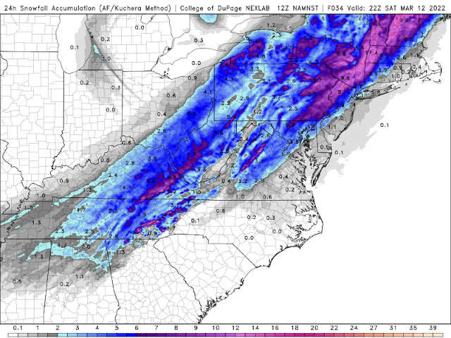
At this point in time, I think it's safe to say that the favored areas to the north and west of the I-95 corridor will do the best in terms of snow totals. Sleet and freezing rain mix potential will cut down the snow totals closer to the metro area as well as to the south and east of the corridor. 

That said, the less snow any one location sees, the more sleet and icing will be possible. Areas near Fredericksburg and running into Southern Maryland have the potential for a SIGNIFICANT icing event after an initial burst of snow. In these areas, there's even the chance at icing accretion of in excess of a quarter inch. This could lead to power outages in areas hardest hit. 

Conditions may vary greatly over relatively short distances. Thus, your exact location will have large impacts to your exact forecast. I'll do my best to break it down here - apologies if your exact location is not mentioned. 

I-95 Corridor (including areas like Silver Spring, Laurel, and running up towards Baltimore)

2-4 inches of snowfall seems probable. After that, some accumulation of sleet (possibly significant) may occur to give a "crust" to the snow. Additionally, a little glaze (up to a tenth of an inch or so) will be possible to top it all off. A true, "kitchen sink" of precipitation types and NOT fun for driving or even walking. 

North and West Zones (including areas like Frederick, Westminster, Sugarloaf Mountain, Damascus etc - think places like Frederick and Carroll County in MD and Loudoun in VA)

4-8 inches of snowfall with isolated totals to 10 inches. This area may not see much mixing at all - but a little sleet is possible - especially the further south and east you get (closer to the first zone up above). This area should see a storm system more heavily weighted towards snow. Power outage risk should be much lower for these places.

South and East Zones (including areas like Fredericksburg, Charles County, Calvert/St. Mary's)

1-4 inches of snowfall with the most likely being in the 1-3 range. Sleet may become the predominant precipitation type pretty quickly in this area. Even then, a transition to freezing rain may occur much sooner than the other areas listed. This is dangerous as it will create the potential for a significant ice storm component. At least a tenth of an inch of ice, with the potential for four tenths (perhaps even a half inch in spots) will be possible here. This will be enough to cause potential power outages and MAJOR travel concerns. Folks in this area should at least PREPARE for the potential of outages. 

***

Of course, all of the forecast hinges on how deep and how far north the warm layer above the surface gets. Confidence is high that this storm will have a good supply of fresh cold air to work with at the surface. But there will be some warmer layers of the atmosphere up near the 700mb level that will be the cause of the mixed precip. If these layers are only thin and not too warm, sleet may be predominate in the mixing. However, if the warm layer is on the warmer or thicker side, freezing rain would become more probable. These are factors that are difficult to forecast even at shorter ranges. 

Stay tuned for any refinements or updates to the forecast. This should be a pretty significant/high-impact winter storm for the region. There's the potential for more "waves" behind this system. It's possible these will favor plain rain, though. 


Wednesday, February 10, 2021

Another Two Part Winter Event

The National Weather Service has posted a *Winter Weather Advisory* for most of the area for tonight into tomorrow. All indications are that a slug of snowfall will impact the area from this evening into tomorrow morning. That being said, most guidance has converged on lower snow totals than were seen as being possible earlier in the week. Even so, the Euro model still indicates a shot at low-end warning criteria. In general, I think the NWS call for 1-3 inches of snow tonight is solid. I think it could push into the 2-4 inch range in spots that get better snowfall rates. 

The second wave looks to miss the DC-Baltimore corridor to the south. However, it's not out of the range of possibilities for this to trend back north. This second part of the system would be from later on Thursday and into Friday. 

TL;DR - A general 1-3 inches for much of the area tonight into tomorrow. Roads may be dangerous for travel. Some areas could see a bit higher. The second wave is still uncertain but for now, looks to miss. 

Tuesday, February 9, 2021

Long Duration Winter Storm Possible

Confidence is high that winter weather will impact the region once again this week. Currently, it appears that snow will develop from west to east across the area on Wednesday afternoon or evening. There continues to be some model disagreement with regards to exact details. This storm system is actually two "waves," and one may become dominant while one reduce in intensity. For this reason, while the odds for winter precipitation are high, the confidence in the exact timing or amounts are less certain. 

The 06z NAM model run from early morning on 2/9. This shows the progression that this model thinks is possible for the winter weather event for Wed-Fri. (Source: Pivotal Weather)

The 06z RGEM model from early morning on 2/9. This shows another model's take on what may transpire with the storm system for Wed-Fri. (Source: Pivotal Weather)

The 06z GFS model run from early on 2/9. This is just another example of another forecast model trying to crunch the numbers to determine what may happen for our next winter storm. (Source: Pivotal Weather)


You can see from the above forecast model loops, that the timing and intensity varies from one model to the next. However, there is a good chance at 1" or more of snowfall areawide (with the usual exceptions perhaps being to the areas south and east of the metro corridor). I'd even go farther and say that the chance for 2" or more are also quite high. Beyond that, a lot will rely on how potent each of the waves turns out to be in reality. This could be yet another situation of a winter storm that has a slug of snow, a lull and then perhaps additional snowfall with wave two. 

There is a chance that this could be a 4-8" snowstorm when all is said and done. Some mixing will be possible to the south and east. 

Taking a blend of various models gives the area a very healthy snowstorm. For now...I'd forecast 2+ inches with this system and leave it at that until some additional clarity is given by short term forecasting. 

"National Blend of Models" product from Pivotal Weather. This is a blended map showing what a blend of various weather models thinks will occur. This *could* be on the high end IF the system becomes weaker than modeled.


Looking even further ahead...there appears to be winter storm threats (very low confidence forecast at this time) for the weekend and then again Tue/Wed of next week. There's some early indication that significant ice could be in play for the weekend system...but of course it is too early to say with any sort of certainty. 

The bottom line is that we should continue to see a parade of at least THREATS for winter storms. Whether these pan out remains to be seen. However, the pattern certainly supports continued attacks by Old Man Winter. I'll continue to keep you updated as each system gets closer in time.