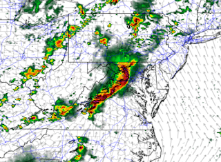
Severe weather will threaten the region this afternoon and evening. There is the potential for the most significant severe weather episode in this area in the past 10 years today. That being said, some uncertainty and complicating factors remain to be worked out.
The primary potentially limiting factor for severe weather will be morning clouds and/or rain. If clouds and precipitation do not clear out of the area by late morning, instability could be reduced enough to reduce the overall severe threat. The expectation is that regardless of amount of sun, SOME threat for severe thunderstorms will exist...but sunshine will only serve to increase the threat.
At the time of this writing, the Storm Prediction Center has outlooked the "bullseye" of the severe weather risk for the DC/Baltimore area and surrounding areas. See the purple/pink area highlighted below.
 |
| The purple/pink area is where the Storm Prediction Center has highlighted the greatest risk. |
ALL severe weather types (damaging wind, hail and tornadoes) will be possible with the storms this afternoon. Of course, damaging wind will be the greatest threat, but low level shear is such that tornadoes can also spin up either in a line of storms, or in discrete cells that may form ahead of a more organized line.
The 0z high-resolution NAM model depicts a very dangerous line of thunderstorms raking through the area in the early evening hours (see below).
One thing to keep in mind is that often times, storms tend to develop or come through the area a bit ahead of schedule. Therefore, while some modeling suggests 6-8pm as a timeframe for worst weather for the immediate metro area, I would be inclined to think it could be a bit earlier than that. Nonetheless, the time period from 2pm until 8pm bears watching - as any time in that timeframe could feature dangerous weather.
People will want to have multiple ways to receive watches, warnings and alerts. There will also be a non-zero flash flooding threat as well...so please DO NOT drive through any flooded roadways. Don't become a statistic.
I would strongly suggest if possible, not being on the roads whenever this line of storms forms/moves through. Traffic is likely to be interrupted by both the rainfall as well as any associated damage. Power outages will also be likely in areas that receive the most significant weather. Charge your phones and portable battery packs NOW - so that you have them in the event of an outage.
Stay safe!


No comments:
Post a Comment